Beyond Maps: The Multifaceted Impact of GIS Software on Indian Industries
From mapping pumps to track pandemic outbreaks at the initial stage, to dynamic and comprehensive event mapping, both digitally and dynamically, GIS technology & Spatial Analysis have marked a significant transformative journey across various specific applications. Nowadays, GIS not only serves as mapping software but has also evolved to offer numerous applications across various industrial fields. The GIS technology has proven its capabilities across multiple domains such as infrastructure development, water resources management, forest conservation, mining operations, electric and gas utilities, telecommunications, and many more. As a developing country, India is adopting various advanced technologies for efficient & effective development activities, and the GIS technology has aided India’s development. Since the last few years, GIS has been welcomed by the Indian Government, and support for indigenous products has been provided to boost the domestic manufacturing sector, under the Make in India initiative. In this regard, we are going to discuss the multifaceted impact of the IGiS (Integrated GIS and Image Processing Software), an indigenous platform, that can directly/ indirectly play an important role in Indian Industrial Development Activities.
Expanding Horizons: GIS Beyond Cartography
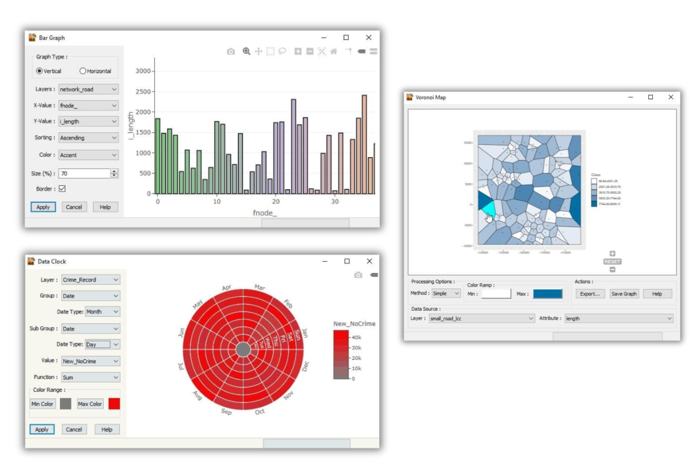
Traditionally, GIS was associated with cartography and map-making. However, its true potential goes beyond plotting geographical boundaries and locations. In India, IGiS software has evolved into a dynamic tool capable of analyzing, interpreting, and visualizing complex spatial data. It aids in identifying patterns, trends, and correlations within geographical contexts, offering insights crucial for decision-makers in various industries.
Agriculture: Transforming Farming Practices
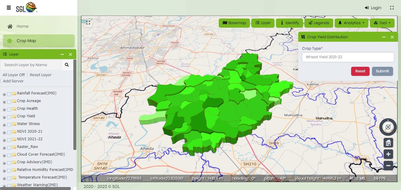
In the Indian agricultural landscape, GIS technology has emerged as a game-changer. By integrating geospatial data with agricultural practices, farmers and policymakers can optimize crop management, assess soil fertility, monitor irrigation systems, and predict crop yield. IGiS provides support for various advanced analyses to digitally map crops, crop acreage estimation, crop yield estimation, crop health & damage assessment, etc. Thus, it empowers stakeholders to make informed decisions regarding crop selection, resource allocation, and land use planning, thereby enhancing agricultural productivity and sustainability.
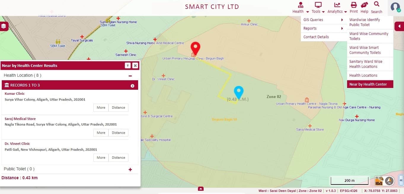
Healthcare: Enhancing Accessibility and Planning
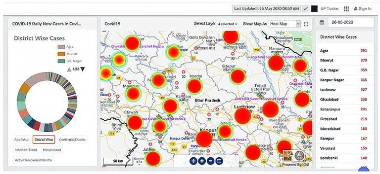
IGIS software can make a significant impact on healthcare in India. By mapping healthcare facilities, disease outbreaks, and demographic data, it facilitates better resource allocation and healthcare planning. Location-based analysis helps in identifying areas with inadequate healthcare access, enabling authorities to strategize the placement of new medical facilities and allocate resources efficiently. During health crises, IGIS assists in tracking the spread of diseases, aiding timely intervention and containment measures. Additionally, the enterprise-level solution of IGiS facilitates various monitoring and management activities at the organizational level.
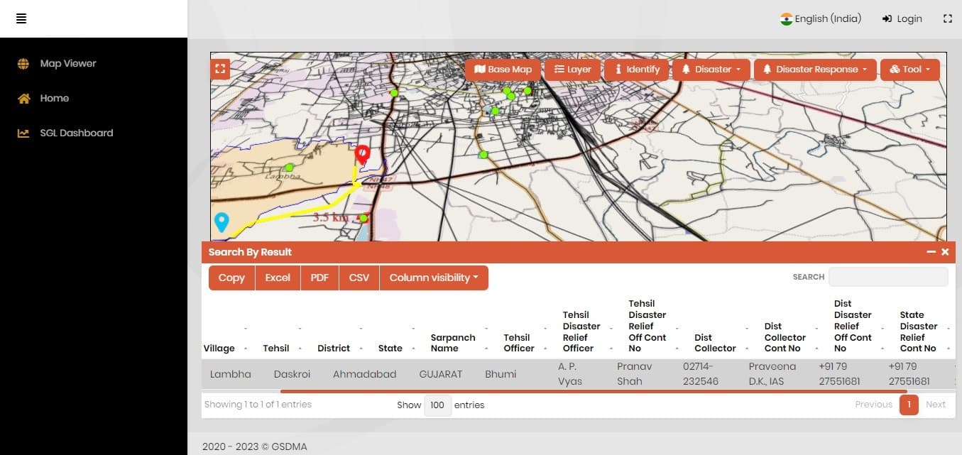
Disaster Management: Mitigating Risks and Enhancing Preparedness
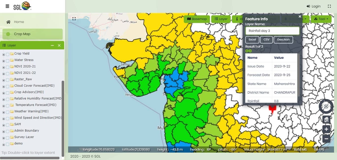
India, prone to various natural disasters, benefits immensely from GIS technology in disaster management. Through spatial analysis and predictive modelling, IGiS supports authorities to identify vulnerable areas, assess risks, and develop contingency plans. Real-time mapping during disasters aids in evacuation planning, resource allocation, and post-disaster recovery efforts. Thus, GIS plays a pivotal role in minimizing the impact of disasters and enhancing preparedness to respond effectively.
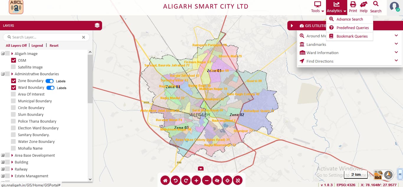
Smart Cities: Planning and Monitoring of Urban Areas
Geospatial techniques have become essential tools in modern urban planning and monitoring. The capacity to gather, analyse, and visualize both spatial and non-spatial data empowers urban planners, policymakers, and authorities to make well-informed decisions for sustainable and effective urban development. IGiS significantly improves the precision of urban plans, facilitates infrastructure management, optimizes resource allocation, and encourages public engagement. The Enterprise-based IGiS Platform offers a comprehensive approach to address the intricate challenges arising from rapid urbanization, encompassing smart city planning, infrastructure management, and land management. Consequently, urban planners can craft thoughtfully designed, resilient, and liveable cities that meet the needs of both present and future generations by leveraging the capabilities of the IGiS Platform.
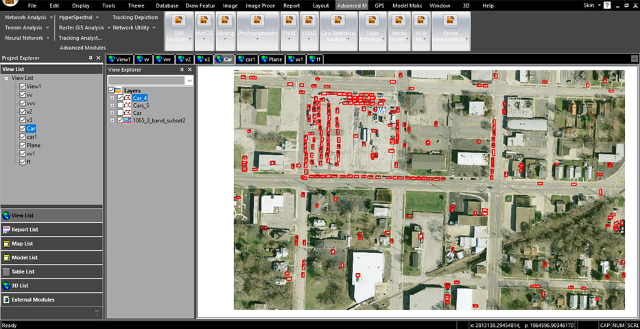
Defence Sector: Advanced cartography, planning, and monitoring
For centuries, the military has relied on cartography for various purposes, from conveying troop movements to coordinating airstrikes, harnessing the precision of map-based communication for successful military outcomes. The evolution of cartography has not only influenced improved decision-making but also, the advancement of GIS technology has significantly impacted military operations and applications. Nowadays, GIS has become essential in the defence sector, leading to a transformation in military strategies. By integrating spatial data, satellite imagery, and advanced technology, GIS empower defence forces to improve their situational awareness, elevate decision-making processes, and enhance overall operational effectiveness in dynamic wartime situations. IGiS can be used in various military applications such as its out-of-the-box Geo-Dristhi module (AI/ML-based object identification tools), and Automatic Feature Extraction (AFE) based Image Processing module, serves the purpose of target identification and detection. Additionally, the department-specific module of the software supports enhanced planning of minefields based on military standard protocols along with, planning and designing the escape/ bypass route with different parameters defined by the users.
Mining Applications
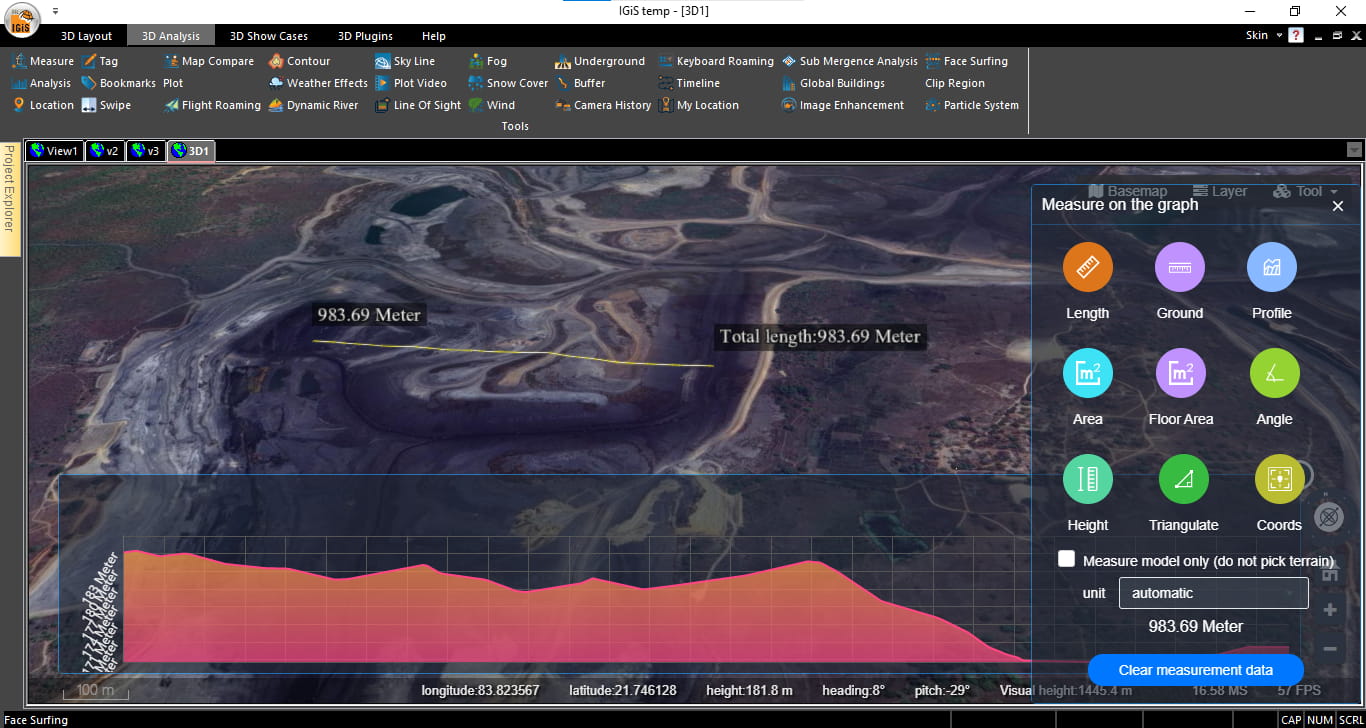
IGiS platform offers numerous industry-specific tailored solutions for the mining sector, for addressing mining-related challenges such as, Potential Mining area identification, Environmental monitoring, Mining site suitability, Infrastructure Management, Asset Management, evaluation of potential environmental pollutants, etc. Moreover, the tools for advanced analyses present within the software such as, 3D-based volumetric analysis, on-the-fly profile generation, cut & fill analysis provides significant insights related to a mine area for planning and maintaining various activities. It also supports finding the shortest path, and optimized routes that result in cost optimization in transporting the materials. Additionally, the in-built indices for clay-mineral, iron-oxide identification assist in locating potential mining areas through the analysis of multi-spectral satellite images.
Forest Management:
GIS play a crucial role in modern forestry management, offering powerful and versatile toolset for understanding, analysing, and optimizing the complex interactions within forest ecosystems. Some of the major innovative solutions of IGiS Technology in forest management are Forest Classification, Land Management, Forest health monitoring through various in-built indices, Forest fire detection, Damage Monitoring, and Suitable site selection for plantation.
Integration across Industries: The Growing Significance
The integration of GIS technology across multiple sectors in India exemplifies its growing significance. Its application extends beyond individual industries, fostering collaboration and data sharing between sectors. The SOA architecture of the IGiS Platform provides facilities for real-time updation of field information by integrating other sensors for enhanced decision-making activities. Such as, combining agricultural data with weather patterns or soil quality information can facilitate more comprehensive insights, aiding multiple stakeholders simultaneously. Hence, the integration of GIS with various sectors emphasizes its pivotal role in fostering synergy, optimizing resource management, and enabling informed decision-making across diverse fields, indicating a new era of interconnected and data-driven solutions.
Conclusion: Embracing the Future with GIS
In conclusion, GIS software has transcended its traditional mapping role to become a transformative force across various industries in India. Its ability to analyse spatial data and provide actionable insights has made it an indispensable tool for decision-makers, revolutionizing operational strategies and fostering sustainable development.
As industries continue to evolve and embrace digital transformation, the role of GIS technology is poised to expand further. Leveraging the power of spatial data analytics, India stands at the threshold of a new era where GIS is not just a tool but an integral part of strategic decision-making processes across diverse sectors, propelling the nation towards progress and innovation.
Latest Blog

Smart Waste Management with GIS
1. Introduction: Waste management entails the responsible collection, processing, and disposal of waste materials with a focus on environmental preservation. Its core objectives include waste reduction, resource recovery, and the....
Read More