Role of GIS in Disaster Management
» 1. Introduction
Today, current technology is advancing in various fields, especially in science and technology, while technological advances pose many challenges. We can use technology to artificially adapt and replicate things, but human beings and other living organisms are more important compared to development. Technological advances also increase the likelihood of disasters. A disaster can be a natural or man-made disaster or an accident, depending on several factors. The main factor is climatic conditions due to human activities such as air, water, and soil pollution. Geographic Information System (GIS) technology plays an important role in combating such disasters. Combining geographic information systems with remote sensing and photogrammetry technologies enables the seamless application of this technology at all stages of the disaster management cycle, from mitigation to recovery processes.
» 2. Geographical Information System (GIS)
Geographic Information Systems are systems that process including, store, manipulate, analyze, integrate, and display data. Disaster prediction can be made using a lot of data, which is available in hundreds of thousands of information such as population and their age, gender details, utility service information, land details of the whole state, and so on.
» 3. Disasters
Natural disasters are dangerous events caused by natural processes on earth. An example of a natural disaster is a flood, earthquake, hurricane/cyclone, volcanic eruption, tsunami, and other geological processes. Man-made or anthropogenic disasters are caused by human activities. Anthropogenic disasters adversely affect humans, other organisms, and finally the ecosystems. Examples of man-made disasters include all types of pollution, nuclear disasters, chemical disasters, biological disasters, terrorism attacks, and other accidental disasters.
• 3.1 Floods – With the help of Remote Sensing & GIS techniques, floods can be predicted. National Disaster Management Authority (NDMA) & State Disaster Management Authority (SDMA) utilized remote sensing techniques in combination with GIS/Photogrammetric technology for Effective & Economic way management of disasters. GIS technology plays a key role in identifying flood-affected locations and providing shelter for affected people. In addition to that, the suitable places for constructing the retaining wall structures and an alternate route for draining the stormwater. This process also helps to create different levels of vulnerability maps which indicate the areas that are frequently affected by floods and base maps (Gram Panchayat, District) to show the location and setup of boats and the rescue team’s plans.
The 3-Dimensional of Flood simulation results will give more strong information to understanding the disaster impacts quickly.
Flash Flood is one type of flood and it is a sudden flood that flushes water paths and is caused by many reasons like Heavy Rain, and melted water from snow/ice on a snowfield. Flash Flood before & after images were shown in Figures 1 & 2 using IGiS (Integrated GIS and Image Processing) software.
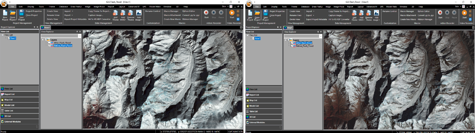 Before Flash Flood | After Flash Flood
• 3.2 Earthquake– It is one of the oldest enemies of humankind and now it is possible to map and analyze earthquakes in a detailed manner. GIS supports national, regional, and local emergency organizations in planning and managing preparatory programs. The GIS-based Urban Information Systems is used to analyze demographic data and infrastructure locations.
Remote sensing and GIS Technology provides the exact position of the spatial data of historical sites. The vision of remote sensing and GIS technology is to visualize the critical vulnerabilities & damages and reduce the impact of the disaster. The GIS Technology results could be responded to quickly during the disaster.
Experience has shown that earthquake deaths can increase due to secondary disasters such as tsunamis and fires. Buffer analysis serves as a good remedy to reduce vulnerabilities to predict the damage that could be caused by a tsunami. The GIS-based Network analysis tool is used to identify the location and routes that provide the fastest response to emergency needs like a hospital, fire station, and so on.
The real-time location tracking platform or web/mobile GIS-based applications are enabled to interact with the maps which contain the details of the earthquake location & its intensity, health facility, nearby base camp information, and Damage assessment. The GIS-based application also acts as a collective platform for data gathering around the incident of infrastructure damage or fire and information dissemination to relief teams involved in providing aid to those affected by the disasters.
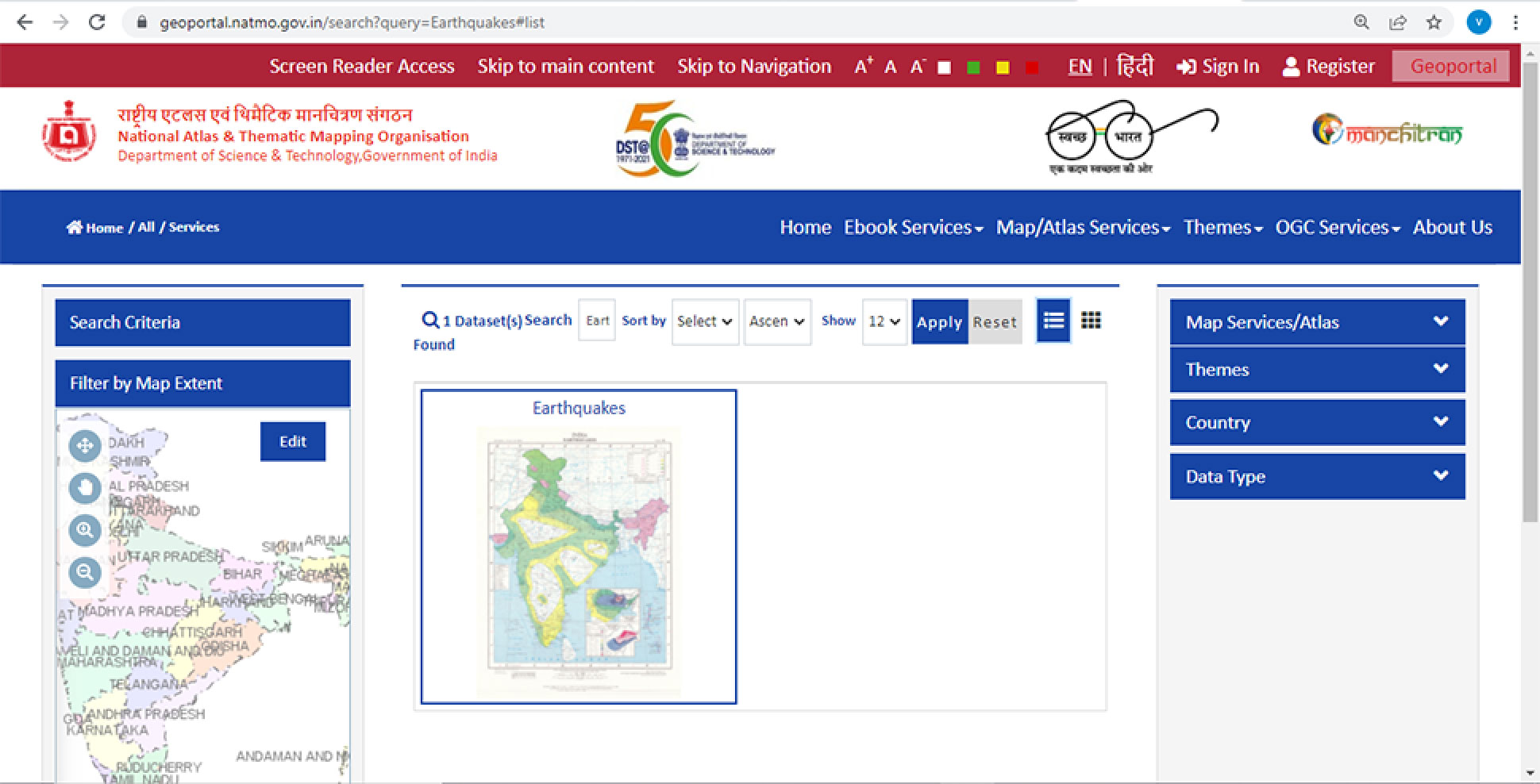
The Figure shows the NATMO Geoportal Powered by SGL and the website containing the Earthquake map.
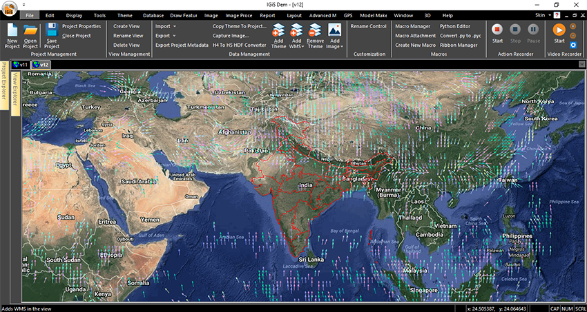
• 3.3 Cyclone – It is the most destructive force of nature, causing widespread loss. Remote Sensing technology is used to monitor & collect acute information for the entire earth globe concerning the topography and meteorological/climate data. The Temporal data of the same place has become strong and dominant in determining as well as forecasting the natural calamities for the environment & ecosystem protection and development.
Similarly, Remote Sensing & GIS technology acting a major role in other disasters like Drought, Heatwaves & Cold waves, Climate Change, and Global Warming & its Effects.
The pollution disasters like air pollution, water pollution, and soil pollution are consequences of climate and Global warming effects. These types of disasters are based on the meteorological conditions of the locations/place.
GIS technology has been vital for emergency preparedness through planning & execution and has saved many lives in previously occurred cyclones. It has improved certain extended limits like environmental understanding, strategic decision making, monitoring of climate change impact, and ascertaining future risks. It is mathematics functional algorithms to analyze the geo-spatial data and display the output in a visual format.
The data is visualized and patterns & their relationships can be identified. Government agencies, as well as NGOs that support disaster management, can benefit from this technology because they know which regions are most affected.
• 3.4 Landslides & Avalanches – The historic data can be accessed by GIS technology and it will give more awareness to society when the government sectors/rescue teams display the vulnerability maps and announce the Risk time by the climates.
GIS also integrates qualitative and quantitative data through spatial relationships. The other excellent features such as Query builder, Overlay Analysis, Raster & Vector analysis, and the user interfaces permit to performance of the query-based analysis in multiple thematic layers.
The spatial analysis such as developing different theme maps like Elevation, Slope, Aspect, and Hill shade using terrain analyst which is very useful in landslide & Avalanches disaster prediction.
Landslide /Avalanche hazard mapping is a typical problem that requires a large database. Subsequent analysis of GIS results allows the users to better understand and visualize problems and results.
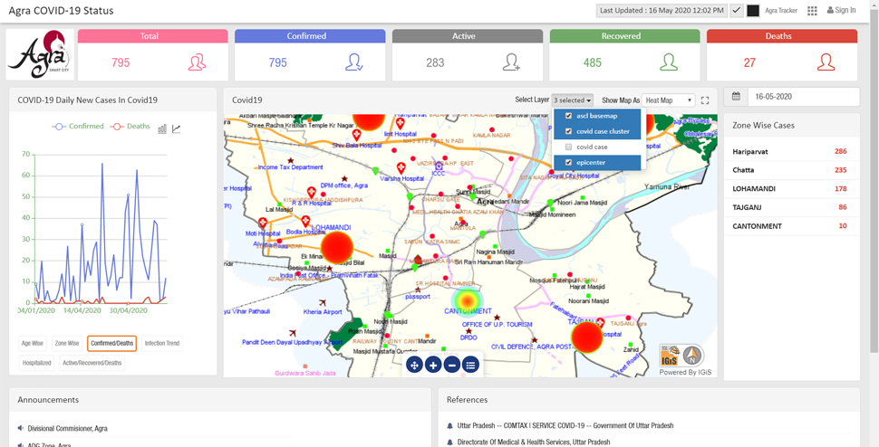
• 3.5 Biological Disasters – COVID-19 is a good example to understand the importance of information through maps. In the healthcare domain, the GIS technology is supported against the global pandemic disease COVID-19. The battle through Mapping of available data like existing COVID Positive cases, quarantine centers, hospital infrastructure capacities, and identifying hotspots using IGIS Based COVID-19 Response & Monitoring Solution. The GIS Real-Time spatial mapping and analysis skills will also act the main role in the efficient distribution of vaccinations.
• 3.6 Accidental disasters – Accidental disasters is occurred due to the following reasons: Process and safety systems failures, Human/Technical/Management errors, the Induced effect of natural calamities, Hazardous waste processing/ disposal, and Terrorist attacks/ unrest leading to sabotage. The accidental disaster hotspot identification of the location is used by GIS, GPS, and Telecommunication Technology. The high user interface of mobile-based applications has integrated the technology to provide effective and economical safety to society.
» Disaster Management
Disaster management is having two parts which are Pre-Disaster and Post-Disaster events.
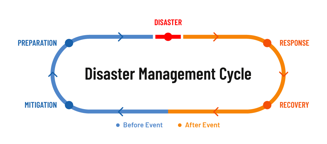
• Pre-Disaster Stage
Mitigation and Preparation process activities need to be planned to reduce the impact of the disaster.
•– Phase 1 – Mitigation: Minimize the effects of the Disasters before their occurrence.
The Central /State Government or local rescue teams take action to save people’s lives, and properties, to reduce the consequence of disasters with help of Geo-Information data. The objective of the Mitigation process is preserved in an optimum way using GIS Technology by adoption and enforcement of land use & zoning practices, implementing and enforcing building codes, Raising of homes in flood-prone areas, and Awareness Program. The Government sector tremendously works in disaster mitigation plans with help of GIS-based forecasted disaster maps efficiently. Making short & long-term continuous preparation of mitigation plans to minimize the impact of the disaster will need to identify the critical areas by its interactive visualization in a geospatial optimized mode.
•– Phase 2 – Preparedness: Involves the development of an emergency operations plan.
Central/provincial or local rescue teams are ready to prepare an emergency operation plan with a disaster response checklist for communities and data share across both government and non-governmental agencies. The development of the geospatial database for infrastructure, and the asset locations, such as generators, construction machinery, medical resources, and shelters.
Post-Disaster Stage
Response and recovery measures are being taken to return to normal life.
•– Phase 3 – Response: Emergency helps the people
In the event of a disaster, people need emergency assistance after the disaster, geospatial data can be used to determine the answers to user questions regarding emergencies like health center operations, temporary potential shelter locations, and so on. The central / state government or relief team address/respond to all those in need of help during the time of the fight against a disaster with of help of GIS Technology.
•– Phase 4 – Recovery: Back to Normal Life after the occurrence of the Disaster Event
The organization/Government provides support to the affected people during the disaster to bring them into their day-to-day routine life using support in an economic, social, and environmental way. GIS provides short-term goals such as environmental monitoring of affected sites, tracking of rehabilitation processes, and economical support for rapid recovery processes. The establishment of Long term vision has to make better recovery & rebuild work and mitigation plans along with GIS technology.
Concluding of Role of GIS in Disaster Management
» GIS technology helps identify disasters before they occur, using forecasts or risk zone maps.
» Remote sensing and GIS technology for Disaster Management create an emergency database for people in need of all assistance in the event of a disaster.
» The emergency database contains information about nearby hospitals, emergency shelters, and more. Disaster risk or impact maps focus on taking corrective action against disasters.
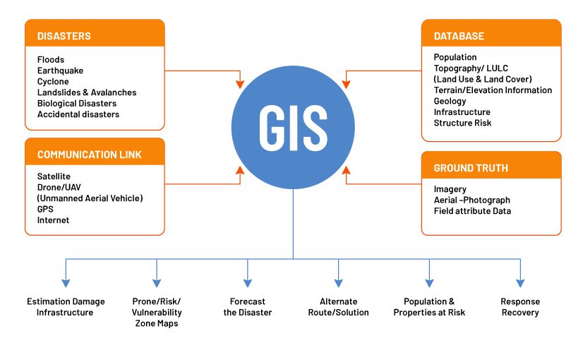
» The GIS Technology is combined with Global Positioning System (GPS), which will help to receive/update the help from disaster rescue teams.
» GIS for Disaster Management uses remote sensing data to forecast climate conditions and climate anomalies at any given point by latitude-longitude coordinates.
» The alternate routes can be created by using Disaster Management technology i.e. GIS for rescuing from disasters.
The details of the disaster like the occurred place, severity level, and how many areas are affected & disaster directions all will be mapped using GIS Technology.
» The GIS Maps will give also historical/past disaster events details, from this disaster management action will be taken more strongly.
» The Risk zone map of disasters may reduce the vulnerability of the disasters.
» In the event of a disaster or post-disaster emergency, GIS technology uses a combination of GPS & 5G to enhance assistance.
» Remote Sensing and GIS technology have strong essence to provide the solution to all types of disasters but only the method, and consideration of the factors are different.
So, disasters occur naturally or accidentally and cannot be stopped, but technology can be used to minimize the impact and damage.
For more such informative content visit our blog and don’t hesitate to connect with us for any questions or queries.
Latest Blog

Smart Waste Management with GIS
1. Introduction: Waste management entails the responsible collection, processing, and disposal of waste materials with a focus on environmental preservation. Its core objectives include waste reduction, resource recovery, and the....
Read More