GIS and Remote Sensing for Effective Forest Fire Management
“A small spark can ignite an entire forest, but vigilance can prevent it.” This saying by Charles Bukowski profoundly illustrates the nature of forest fires.
Forest fires exert a considerable influence on various ecosystems, with far-reaching global consequences, including the emission of greenhouse gases. Despite historical land management practices that have used fire as a tool, shifts in climate and human activity have altered this natural balance. These changes intensify the destructive effects of fires on vegetation, soil quality, and, tragically, the loss of human lives.
India faces escalating risks of forest fires, with significant portions of its forested regions categorized as highly or extremely fire-prone. According to the State of Forest Report 2021 (SoFR 2021), approximately 2.8% of India’s land area, covering around 20,074 square kilometers, is classified as extremely fire-prone forest cover. An additional 7.85% or 56,049 square kilometres fall under the category of very highly fire-prone. In total, roughly 22% of India’s forested areas are at high risk of fires.
The Forest Survey of India’s Volume 1 No. 1 in 2019 revealed that out of 69,652 forested grids (each covering an area of 5 kilometers by 5 kilometers) in India during the fire seasons from 2004 to 2017, approximately 42.13%, or 29,345 grids, experienced forest fires. This data highlights the fact that over 733,625 square kilometers were affected by forest fires over this 13-year period. The need for advanced tools to manage forest fires effectively is undeniable, and this is where the integration of Remote Sensing and Geographic Information Systems (GIS) plays a crucial role.
The Role of Remote Sensing and GIS for Forest Fire Management
Given the urgency of the situation, comprehensive monitoring of land use, from local to global scales, has become essential. Earth observation data is essential for monitoring fire, predicting hazards, and creating risk maps. These geospatial models use diverse factors like vegetation, topography, and proximity to human activities to calculate risk estimates for specific regions.
Satellite data plays a pivotal role in measuring fire severity and mapping burnt areas. This data forms the basis for predictive risk assessments, utilizing parameters such as surface temperature, vegetation indices, and moisture metrics. To optimize the use of Remote Sensing and GIS, the IGiS platform offers in-built robust algorithms for identifying high-risk areas for forest fires. IGiS is designed to save time and simplify data analysis by integrating indices like differenced Normalized Burn Ratio (dNBR), Normalized Difference Vegetation Index (NDVI), Relative difference Normalized Burn ratio (RdNBR) etc.
Preparedness and Prevention
Preventive measures such as creating firebreaks, removing combustible materials like dead wood and leaves, hiring forest fire monitors, ensuring equipment readiness, and conducting practice drills are vital to forest fire prevention and preparedness. Integrating these measures with GIS enables efficient disaster preparedness.
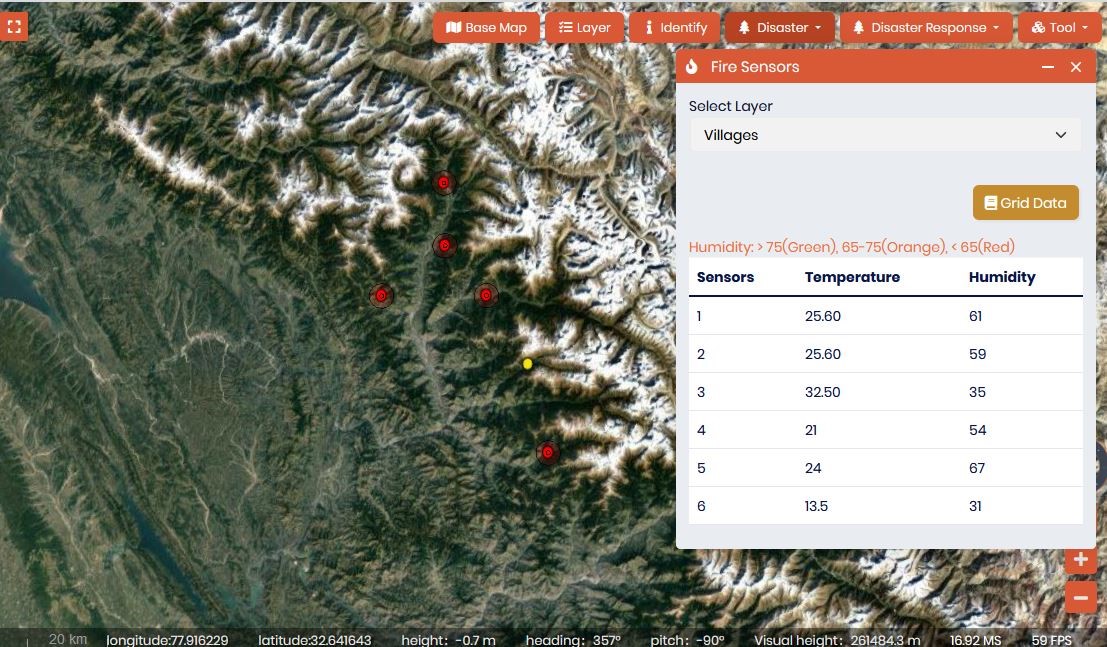
Figure 1: Near Real Time Monitoring the forest temperature using IoT sensor data integrated on GIS based web-portal
The IGiS platform incorporates advanced tools like the Analytical Hierarchy Process (AHP) and Weighted Overlay, allowing users to consider factors such as road proximity, slope, land use, rainfall, and temperature. This integrated data helps in understanding the vulnerabilities and susceptibilities of forest fire risks at a granular level.
By analyzing historical forest fire data, stakeholders can create fire management plans, identify high-risk areas, and disseminate information to the public and other stakeholders through the IGiS Enterprise platform.
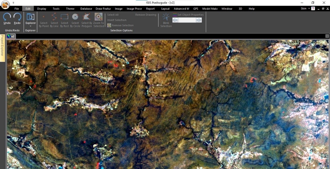
Figure 2: Red Spots showing active fire in Sentinel – 2 satellite image
Data-Driven Prevention and Mitigation
In regions where comprehensive forest fire data is lacking, modern scientific methods are needed to collect, organize, and document relevant information. A robust information database is crucial for formulating effective forest fire management strategies. Analyzing the risk of forest fires and the frequency of fire incidents is essential for taking preventive measures and assessing post-fire degradation.
Continuous surveillance using cameras and IoT sensors, integrated with a web portal, provides real-time information to stakeholders. This data empowers decision-makers with the information they need to respond effectively to forest fires. Standard Operating Procedures (SOPs) can be updated and disseminated in real-time to coordinate responses based on specific forest types and geography. Utilizing GIS, disaster management can be managed at the district, state, and national levels.
Emergency Response and Recovery
Based on a report from the National Disaster Management Authority (NDMA), India experienced a significant surge of 113.74% in forest fires between 2018 and 2019. This alarming increase has notably impacted the forested regions of India’s mountainous states along the Himalayan border, an area already grappling with the challenges of climate change.
The report has linked the loss of forest cover in the Himalayan and North Eastern regions to the intensification of developmental activities and agricultural expansion. Given the nation’s substantial reliance on forests and their deteriorating state, there’s an urgent need for comprehensive recovery initiatives following severe forest fire incidents.
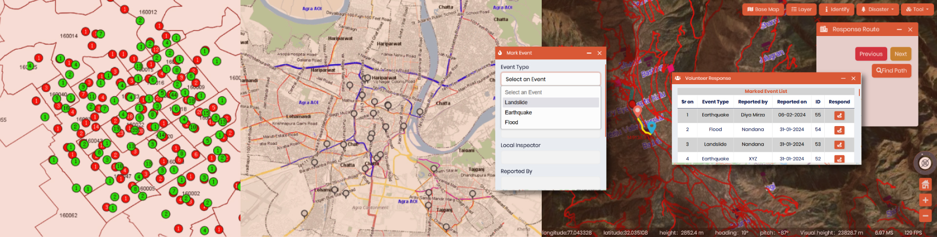
In the event of a forest fire emergency, the IGiS enterprise solution allows stakeholders to activate automated SOPs and action plans. Spatial analysis and heat maps help identify affected areas and deploy resources efficiently. The system can track volunteers and coordinate their efforts.
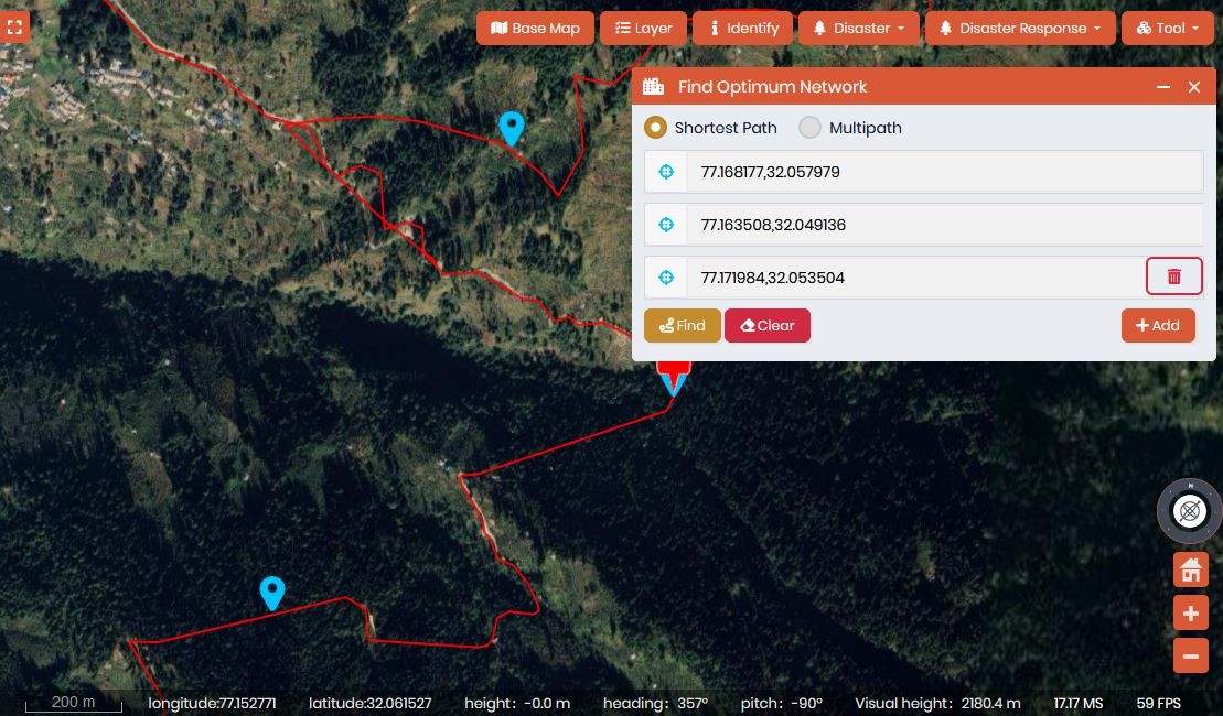
Figure 3 Response route identification during Emergency
Recovery efforts include reporting incidents through IGiS mobile application – QPAD, analyzing affected areas using geotagged photographs, and planning afforestation initiatives based on the damage analysis. This holistic approach is crucial for not only preventing future forest losses but also mitigating the effects of climate change.
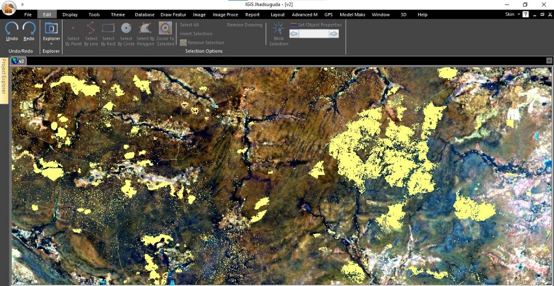
Figure 4 dNBR indices results on true color composite
What Should More Be Done?
The frequency of forest fires in India is on the rise, leading to extensive land destruction year after year. The existing fragmented approach to addressing this issue is primarily responsible for these ongoing failures. What the nation urgently requires is a cohesive national strategy, underpinned by the necessary technical resources, to establish an organized forest fire GIS-based management program.
Key components of such a program should encompass the establishment of strategic fire centres, fostering inter-ministerial coordination, allocating adequate financial resources, investing in human resource development, advancing fire research initiatives, refining fire management strategies, mapping areas vulnerable to fires, releasing Fire Zonation Hazard maps, updating and automating Standard Operating Procedures (SOPs) for emergency response, and conducting extension programs that integrate GIS and remote sensing technologies. These comprehensive efforts are indispensable for effective forest fire management in the country.
Also Read »
Latest Blog
Spatial enablement of real time data and its Applications
In the modern world of Artificial intelligence and virtual reality, although slowly and steadily, real time data ingestion is now becoming a mandate. Although extracting complex insights in real time....
Read More