Spatial enablement of real time data and its Applications
In the modern world of Artificial intelligence and virtual reality, although slowly and steadily, real time data ingestion is now becoming a mandate. Although extracting complex insights in real time may take some time to develop, but its visualisation, on the fly analytics and its role in prompt decision-making has already started making voices around the globe. Things like business intelligence, dynamic data intelligence are not anymore just whispers, rather they are now implemented is real use cases.
In lieu of the above, the spatial enablement has gone beyond horses for courses in last few years. It is in fact now becoming an integral part of any intelligence solution implementation around the world. Be it smart cities and ecosystems, response planning and management or supply chain or FMCG management, Geographical information system or GIS as we call it, has become a vital portion of inclusive solution architecture.
With this base, let us dig down deep what can be achieved through the spatial enablement of real time datasets? What capabilities and industrial use cases be delivered through the technological offering? What could be the go ahead provided the technology and its various applications towards sustainable development based decision making.
What is Real Time Data?
Real-time data refers to information that is continuously updated and available immediately as it is generated or collected. This type of data is often used in various applications where timeliness and accuracy are crucial, such as financial trading, monitoring systems, social media analytics, and sensor networks.
Real-time data is typically processed and analysed quickly to derive insights, make informed decisions, or take immediate actions based on the most current information available. This contrasts with traditional batch processing methods, where data is collected over a period and then analysed later in bulk. These data sets can be of many types ranging from stock market prices, to social media feeds and weather or environmental sensor data.
Spatial Enablement of Real time Data
Spatial enablement of real-time data involves integrating geographical or location-based information with real-time data streams. This integration allows for the visualization, analysis, and interpretation of real-time data in a spatial context, providing insights into how data changes over space and time.
How this enablement can help?
Real-time data sources, such as sensors, IoT devices, or social media feeds, are often associated with specific locations. By integrating this data with geospatial information, such as maps or spatial databases, users can visualize the data in the context of its geographic location. Spatial analytics techniques can be applied to real-time data to uncover spatial patterns, trends, and relationships. For example, analysing real-time traffic data overlaid on a map can reveal congestion hotspots or identify optimal routes for navigation. In addition to it, Geo visualization techniques, such as maps, dashboards, and interactive visualizations, help users understand complex spatial relationships and make informed decisions. Real-time data can be used to power location-based services (LBS), such as real-time navigation, asset tracking, or location-based marketing.
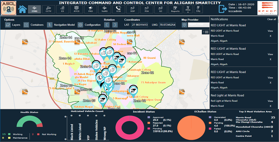
Real Time data and Smart City Monitoring
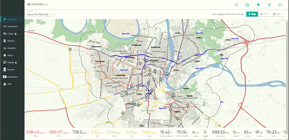
Real-time data plays a critical role in the development and operation of smart cities, where various technologies are leveraged to enhance efficiency, sustainability, and quality of life for residents.
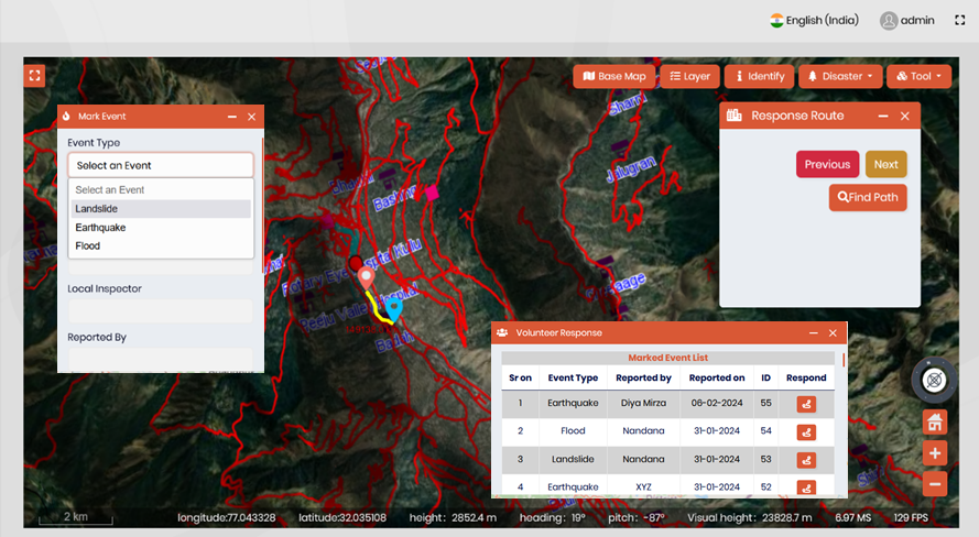
- Urban Infrastructure Monitoring: Real-time data collected through field based GIS enabled mobile application from urban infrastructure, such as roads, bridges, buildings, and utilities, enables the continuous monitoring of their condition and performance. This data, which can be easily in real time integrated with an enterprise solution, help, identify maintenance needs, detect anomalies or failures, and optimize resource allocation for infrastructure management. In addition, integration of live GPS location with enterprise level solution from vehicles on ground can help in managing various city run services.
- Emergency Response and Public Safety: Real-time data from surveillance cameras, emergency call systems, social media feeds, and other sources can be integrated to support Emergency response operations and enhance public safety. This includes real-time monitoring and updation of incidents, predictive analytics for crime prevention, and coordination of emergency services during natural disasters or other crises.
- Environmental Monitoring: Real-time data on air quality, noise levels, temperature, and other environmental parameters can be collected from sensors deployed throughout the city. This data helps city officials and residents understand environmental conditions, identify pollution sources, and take proactive measures to improve air and water quality, enhance public health, and mitigate climate change impacts.
Indian GIS technology and real time data integration
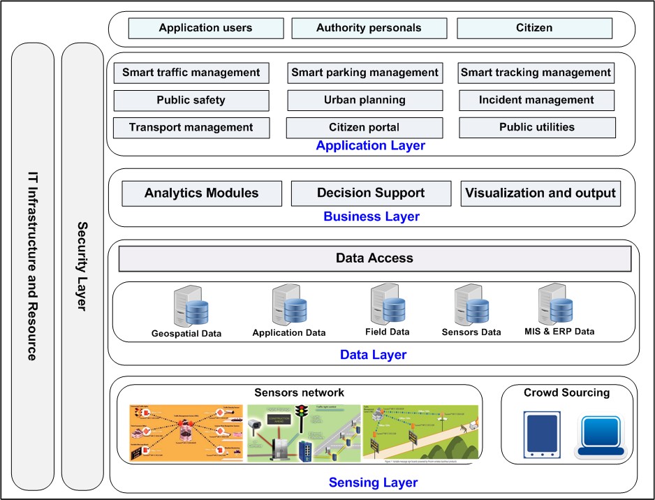
What we saw within the discussions above and all the implementations we saw are made possible with, a fully Indigenous Geo spatial Software known as IGIS i.e. Integrated GIS and Image processing Software. IGIS comes with a plethora of functionalities enabling integration of not only collection of real time data and its visualisation with the analytics but also the integration of sensor information and in lieu enabling decision makers to take informed policy decisions on the go. This is just the beginning of superfluity of applications possible through real time data integration into IGiS.
Stay tuned as IGIS comes up with various more applications with real time data opens up a vast world of possibilities.
Written by Nirav Soni | 29-March-2024
Latest Blog

Smart Waste Management with GIS
1. Introduction: Waste management entails the responsible collection, processing, and disposal of waste materials with a focus on environmental preservation. Its core objectives include waste reduction, resource recovery, and the....
Read More