Empowering smart villages through gis: a geospatial approach to rural development
Introduction
Smart villages are a concept aimed at leveraging technology and innovative solutions to enhance the quality of life and promote sustainable development in rural areas such as the upgradation of rural infrastructure, promote tech integration, and encourage sustainable agriculture, economic diversification, and renewable energy adoption. Not only limiting to that, it also emphasizes access to quality education and healthcare improvement, nurturing community engagement and environmental conservation.
Smart villages offer efficient rural planning and resource management which is an integrated part for modern and up-to-date solutions based on spatial and non-spatial data. Geographic Information System (GIS) supports infrastructure optimization, community asset mapping and monitoring, and land use planning by facilitating infrastructure maintenance and data visualization. It empowers rural communities to make informed decisions, allocate resources efficiently, and improve quality of life, raising a more sustainable and prosperous future.
Understandings about Smart Villages and Rural Development: Core goals and challenges in the context of GIS and Remote Sensing
The National Rurban Mission (NRuM) was launched by the Prime Minister on 2016, with a vision to develop clusters of villages that preserve rural community life while incorporating urban-like facilities. NRuM aims to stimulate local economic development, improve basic services, and create well-planned “Rurban clusters.” The mission’s goals include bridging rural-urban divides, reducing poverty and unemployment, spreading development, and attracting investments in rural areas. Rurban clusters typically consists of geographically contiguous villages with populations ranging from 5,000 to 15,000 in challenging terrains and 25,000 to 50,000 in plain and coastal areas.
Keeping these objectives in consideration GIS can play a crucial role in rural development by providing valuable tools and insights for planning, disaster resilience, decision-making, and resource management in rural areas.
By virtue of GIS functionalities, a Decision Support system (DSS) can be effortlessly envisaged. The DSS focuses on improving the planning, operation, and maintenance of various projects and services. This means that it helps in better strategizing, executing, and sustaining activities undertaken by government departments.
Challenges and Considerations for Smart Village Development
Smart village development is a comprehensive approach that seeks to enhance the quality of life in rural areas by leveraging technology and innovation. However, there are several challenges and considerations that need to be addressed when pursuing smart village initiatives:
- Infrastructure and Connectivity: Rural areas often lack adequate physical infrastructure and reliable internet connectivity. Building the necessary infrastructure is a significant challenge and can be costly.
- Digital Literacy: Many rural residents may lack the digital skills necessary to fully benefit from smart technologies. Education and training programs are needed to bridge this gap.
- Energy Supply: Reliable and sustainable power sources are essential for running technology in rural areas. Access to electricity can be limited, making renewable energy sources an attractive option.
- Environmental Impact: Implementing technology should not harm the local environment. Sustainability and minimizing the carbon footprint are critical.
- Community Involvement: The community’s active participation and engagement are vital. Local residents should be part of the decision-making process and contribute to shaping the development of their villages.
- Scalability: Solutions should be designed with scalability in mind. They should be adaptable for use in different regions and contexts.
- Cultural Considerations: Understanding and respecting local traditions and customs is crucial to gaining the acceptance and trust of the community.
- Monitoring and Evaluation: Regular monitoring and evaluation are essential to assess the impact of smart village projects and make necessary adjustments.
- Long-Term Sustainability: Sustainable development should be a primary goal. Smart village projects should not rely solely on external aid or funding but should be designed to be self-sustaining over time.
Future Prospects and Sustainability for Smart Village Development
The future prospects and sustainability of smart villages are promising, with the potential to address various challenges (as mentioned above section) in rural areas and enhance the quality of life for residents. Decision makers can utilise GIS for trending and innovative solutions for prompt decision making and rural infrastructural development. Following are some key aspects that contribute to the future prospects and sustainability of smart villages in the realm of GIS and Remote sensing Technology.
- Improved Quality of Life: Smart villages aim to provide better access to healthcare, education, clean energy, and digital services. By addressing these basic needs, they can significantly improve the quality of life for rural residents.
- Economic Opportunities: Smart villages can stimulate economic development by promoting entrepreneurship, supporting local industries, and connecting rural businesses to larger markets. This can lead to job creation and increased income for residents.
- Agricultural Innovation: Smart agriculture technologies can help farmers increase crop yields, reduce wastage, and improve farm management practices. This can boost agricultural productivity and food security in rural areas.
- Digital Inclusion: Smart villages can bridge the digital divide by providing internet connectivity and digital literacy programs. This enables residents to access online education, information, and markets, fostering inclusion in the digital economy.
- Sustainable Energy: Many smart villages incorporate renewable energy sources, reducing reliance on fossil fuels and increasing energy sustainability. This is not only environmentally friendly but also cost-effective in the long term.
- Community Engagement: Involving the local community in the planning, implementation, and maintenance of smart village projects is crucial for their sustainability. Residents who feel ownership and have a say in the process are more likely to support and maintain these initiatives.
- Public and Private Partnerships: Collaboration between governments, non-governmental organizations, private sector companies, and academic institutions can bring resources, expertise, and funding to support smart village projects.
- Data-Driven Decision-Making: The collection and analysis of data from smart village initiatives can lead to more informed and effective policymaking and resource allocation, enhancing sustainability.
- Environmental Sustainability: Emphasizing environmental sustainability in smart village projects can help mitigate the impact of climate change and promote eco-friendly practices
- Global Connectivity: The global connectivity and exchange of knowledge can allow smart villages to benefit from best practices and innovations from around the world.
IGiS Software: An Indigenous Solution for Smart Villages and Rural Development
- Rural Electrification: The role of remote sensing and GIS is of utmost significance in both the preparation and execution of projects aimed at electrifying rural areas. Through the utilization of IGiS user can get powerful insights into the topographical characteristics of rural regions which will lead to optimizing the allocation of resources by examining data related to population distribution, existing infrastructure, and environmental variables. Through this technological improvement decision makers can empower themselves to craft comprehensive electrification plans, streamline the management of transmission and distribution networks, and monitor real-time progress, ultimately resulting in cost-effective and sustainable rural electrification endeavours.
- Rural Banking Infrastructure Development: IGiS can enable financial institutions to make informed decisions about the location of bank branches and ATMs in rural areas by providing accurate geospatial data based analysis on population distribution, road network connectivity, finding optimum route for source hub analysis, potential market places for branch establishment, relocation of staffs and enriching the overall performance indicators by assessing the impact of banking initiatives.
- Agricultural Assistance and Damage Assessment: IGiS can assist the agricultural stakeholders in monitoring and respond to various agricultural threats, such as natural disasters, pests, and diseases through the processing of satellites/drones, aerial imagery, damage detection for disasters, crop monitoring for health and growth analysis, yield estimation for economic impact assessment, and pest/disease management. IGiS has out-of-the-box tools like NDVI, NDWI, FAPAR, and Image Classification tools for crop yield estimation and getting meaningful insights from them.
- Accurate and Efficient Agriculture Loan Management: IGiS an indigenously developed software which has all the capabilities to meet the requirements of the financial institutions to assess distribution and current status of the agricultural loan by virtue of thematic representation and proper MIS information. Enabling the centralised Web GIS solution can assist in loan recovery management system in a prompt manner. By assessing the agricultural land pattern and its use, monitoring crop health, and integrating historical weather data and its trend analysis, help to accomplish risks/threads for agricultural products under a single platform. Along with the Real-time data fetching and analysis enables quick responses to various issues & helps to mitigate risks and supports informed decisions on loan restructuring.
- Rural Land Record Management: Land is the most significant part of the rural economy. GIS is vital for land record management by enabling different data integration like ownership information, Land use and Land Cover type, accurate parcel digitization and identification, linking up ownership records, to create a comprehensive and centralised system with spatial information. IGiS supports spatial analysis for assessing land classification, centralised database management for taxation, zoning, categorization of lands, for different analytical outputs. It also aids in finding the encroachments, ownership dispute, mutation related issues etc. under the single platform which leads to transparency in e-governance.
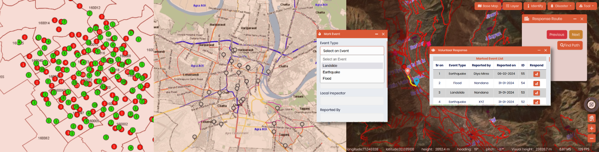
- Disaster Management & Mitigation: Disaster Management & Mitigation is very much important for the rural economy as well as to safeguard the rural infrastructures. IGiS provides vital insights for disaster management, offering it’s out of the box tools to analyze, visualize and processing of spatial data. Additionally its supports risk assessment simulation, early weather prediction, response planning, resource management, and damage assessment by utilising different tools like thematic mapping, geo-processing tools, image processing modules, disaster mapping and its visual and analytical statistics generation, 3D based simulation, on the fly slope-aspect generation, network analysis for resource planning and optimum path identification etc.
- Field data collection and Citizen centric Mobile Application: IGiS also provides the provision to capture field data related to land information, ownership record collection, tax payment status, crop type and its associated information by its in-house Integrated Survey Solution Mobile Application. It enables efficient data collection with real-time updates and geo-tagged photos or videos along with spatial analytical capabilities, facilitating decision-making and data validation.
Alongside, on the citizen-centric side, it engages the public by providing accessible location-specific information, allowing different service requests and grievances which leads to transparency in the whole process flow of tax collection and maintenance system. Overall, these apps aids in bridging the gap between fieldwork and community engagement.
Conclusion
With the progress of time, technological advancement has also reached to the rural sectors and enriched the quality of the life of the rural dwellers. “The future of India lies in its villages” – Mahatma Gandhi” this line signifies the importance of village economy in India’s growth. While Government also pushing the Indigenous technology and its active participation in economic growth, it would not be possible without the help of rural assistance and in this context IGiS emerges as the one-point geomatics solution to cater the need of the hour and fasten the growth of rural economy by utilising the advantages of Geo-spatial assistance and scientific approach towards decision making and its prompt implementation.
Latest Blog
Spatial enablement of real time data and its Applications
In the modern world of Artificial intelligence and virtual reality, although slowly and steadily, real time data ingestion is now becoming a mandate. Although extracting complex insights in real time....
Read More