Asset Tracking Analysis & Management with GIS Based Asset Management
As a school student how often I had cursed the Municipal Corporation for the repaired and resurfaced roads that became eyesores within a week. Not because they were badly done but because some other department dug up the same road for laying some underground pipelines. This was in the late sixties in Bombay. The story repeats in Ahmedabad where all of a sudden, the internet conchs out only to realise that the smooth road on which I was driving for a week has been dug up and the optical fiber has got cut. Having worked in the field of GIS for more than 30 years I would say it is sheer mismanagement of assets within the Corporation itself. A GIS based asset management system with a significant level of transparency can certainly avoid such wasteful situations. Let us see how this is possible.
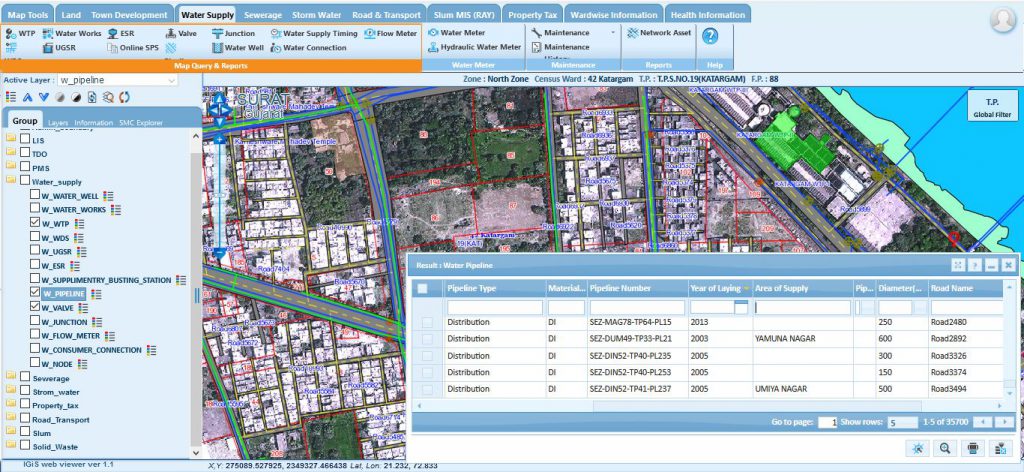
The Corporation has a geo-spatial database of all its assets which includes but is not limited to water supply pipelines, sewerage lines, telephone cables (pre-cell phone times), electricity lines and connections to streetlights and road networks. Each department publishes its short term and long-term plans which are accessible by all. The water supply department planning for any activity requiring digging of road synchronizes its task with the activity of the roads department. What an ideal situation! But definitely it is feasible. This is and should be the net result of the GIS smart city mission of the Niti Aayog.
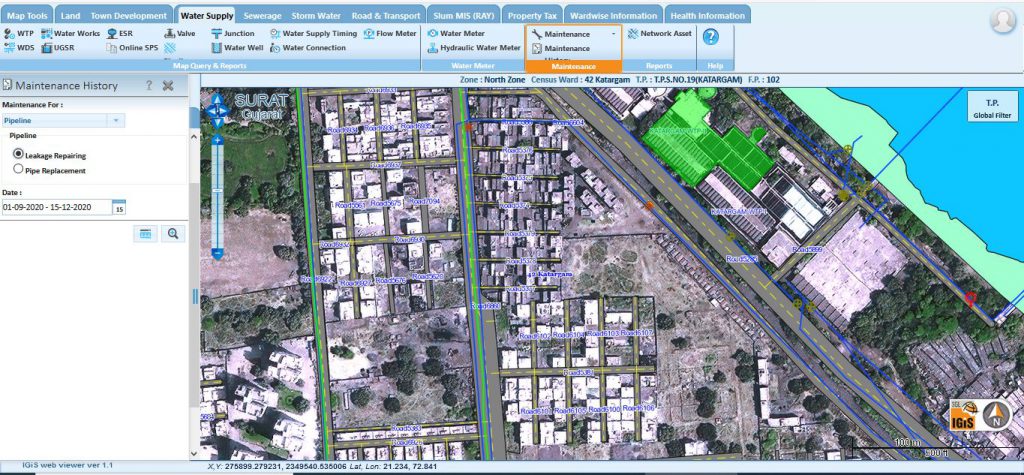
‘Go Digital’ is the hash tag. The way out is to have a decision support system for conducting all operations and managing all assets through a transparent digital record of all activities. The decision making will require asset tracking with details related to installation history, warranty period, planned maintenance, condition and age of the asset, unplanned incidents and faults, actual maintenance (when and by whom, scheduled or repair work), valuation, cost of ownership, insurance status, legal compliance and so on. It should not be simply a matter of looking at a checklist of features in the software system. Many of the asset relationships are not standard configurations out of the box. The software system has to be capable of these configuration needs. So for any asset management system a clear definition of what asset is to be managed and what attributes are required have to be carefully spelled out.
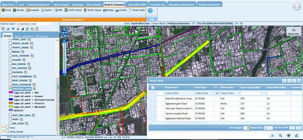
Irrespective of whether you are a private organization, business, or a public agency, if you have physical assets, they need to have regular maintenance to ensure they are working properly. This will extend the life of the said asset thereby reducing the lifetime cost. It will also ensure that the asset does not pose a safety risk. The responsibility of your organization defines what assets are to be managed. For a municipal corporation the asset would be utilities like drinking water, sewer or storm water, street information like paving, sidewalks, street lights, electricity, telephone lines, cell towers, city halls, fire departments, police stations, parks, playgrounds and every other thing maintained by the corporation.
Property tax is a major source of income for the city corporation. High resolution satellite data-based building footprints can be used to ensure that property tax of each and every property is received. If the managing entity is a goods carrier it could be a fleet of vehicles, or real estate both land and buildings. In the case of a school or a university many aspects of the city also apply as a campus has the same infrastructure with the addition of buildings and classrooms and specialized networks.
The advent of IoT has brought in a paradigm shift in the manner in which assets are managed. One of the most promising application areas of the Internet of Things (IoT) is asset tracking. The old way of managing assets (which is how many companies still manage their assets) is to use siloed systems, such as handwritten lists or Excel sheets, to keep track of the assets’ information. Such systems are inefficient and vulnerable to errors, but they’re better than not having any system at all. These manual methods are usually very burdening for asset managers who are responsible for keeping asset records up-to-date and answering questions about assets’ whereabouts. IoT-enabled asset management solutions add automation and intelligence to the system through the use of IoT sensors.
Based on the gathered data, IoT-enabled asset management solutions provide companies with real-time alerts, predictive analytics, automatic reporting, data insights and more.
Typical use cases for IoT-enabled asset management are:
Locations: Automatic location data, asset tracking and geofencing solutions (e.g. utilizing GPS trackers).
Usage hours: Automatic tracking of usage hours and notifications about reached threshold values (e.g. acceleration sensors).
Warehouse inventory: Automatic warehouse inventories without any separate inventory events (e.g. Bluetooth low energy beacons).
Material flows: Automatic tracking and reporting of material flows (e.g. RFID tags).
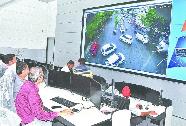
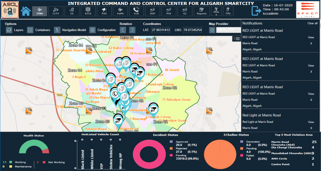
Currently, under the Smart City mission, where Scanpoint Geomatics Limited has played a major role in building the geo spatial database on IGiS platform and integrating the same with the Integrated Command and Control Centre, the IoT devices are being used for traffic management, smart parking, variable message displays, managing red signal violations, emergency call boxes, smart street lighting, smart electrical meters and smart water meters energy management sensors and sensors for intelligent buildings.
The USP of a GIS based system is telling you the ‘where’ of all things. This can be fully exploited in filling in the market and service gaps by understanding where customers, facilities and competitors are by using address locations, spatial database management and query tools. i.e. A company can have an educated decision on where to establish their new assets.
Let us understand some of the GIS techniques that are applied in asset management software. Generation of heat map, a standard GIS function, of territories with high customer demand. Heat maps allow you to determine how to distribute and adjust technician territories based on customer demand. Better service capacity planning is a key aspect of effective mobile field workforce management. Route optimization, a typical GIS feature is another function used frequently. One can select clusters of job and run them through an automated route optimization routine that recommends the optimum route to minimize travel time. Spatial proximity analysis, again a standard GIS feature, using buffer, near, select by location, create Thiessen Polygons, density analysis, make closest facility layer options. One can examine spatial distribution relationships between datasets, answering questions such as: “How far is this feature from the other feature?”; “How many homes fall within this particular fire protection zone?”; “What is the most cost-efficient delivery area based upon our delivery fee?”; and “How long does it take to drive from point A to point B?”.
GIS mapping can drive the improvement of asset management practices in the way it configures and collects data. Without collecting asset data, organizations will struggle to effectively strategize for their asset management program.
Here are the top Important Applications of GIS in the industry.
Latest Blog

Smart Waste Management with GIS
1. Introduction: Waste management entails the responsible collection, processing, and disposal of waste materials with a focus on environmental preservation. Its core objectives include waste reduction, resource recovery, and the....
Read More