Photogrammetry for Terrain Modelling
The earth’s surface from one place to other consists of continuous and abrupt changes in elevation and individuals as well as societies have to deal with them. Water flows downwards from the mountains and hills making its way from streams to rivers, which take the form of a delta to end in the sea. Acquisition and representation of Three-Dimensional (3D) ground information has been an important aspect of studies and work related to the planetary surface. Knowledge of the terrain is a prime factor in planetary exploration and research.
In the beginning of the 1950s, photogrammetry was widely used to collect data for highway designing. Roberts (1957) conceptualized a new tool to acquire data for planning and designing in highway engineering by using digital computers with Photogrammetry. Miller & Laflamme (1958) proposed and elaborated the concept of the Digital Terrain Model (DTM) by defining it as statistical representation of the continuous surface of the ground by large number of selected points with known X, Y and Z coordinates.
Since Miller & Laflamme (1958) proposed the term DTM, within the development period of 55 years, some other popular terms i.e. Digital Elevation Models (DEM’s) and Digital Surface Models (DSMs) came into existence.
However, the use of these terms DTM, DEM and DSM has been confusing and often assumed to be synonymous. Maune et al., (2001) described these three terms as follows (Table 1):
Table 1:
Definitions of DEM, DSM and DTM
| Term | Definition |
| DTM | “DTM is a synonym of bare-earth DEM”. |
| DEM | “Generic term covering digital topographic (and bathymetric) data in all its various forms as well as the method(s) for interpreting implicitly the elevations between observations”. |
| DSM | “Model depicting elevations of the top of reflective surfaces, such as buildings and vegetation”. |
Digital representation of the Earth’s surface topography has always been an important focus in geography and surveying (Singh et al., 2015). With the growing geospatial industry and advancement in technology, DEM has become important in many other application areas also. New demands for high accuracy and high resolution DEMs are raised by awide variety of users. Generating high-resolution DEM data is therefore a big need. Amongst various methods for generating DEM/DTM, photogrammetry is becoming a more popular, efficient and cheaper solution.
The expression, photogrammetry was first used by a Prussian architect, “Albrecht Meydenbauer” in 1867 who fashioned some of the earliest topographic maps and elevation drawings. The main aim of photogrammetry, since inception, has been the production of topographic maps, preferably at a large scale. With the advent of “analytical stereo-plotters”, the stereo aerial photography can be used to extract the elevation data in the form of contours. DEM generation is generally computer assisted due to process automation accompanied by development of digital aerial imagery. The generation of a DEM from digital aerial or satellite imagery is today a fully automatic batch process with the resulting elevation model often employed to support ortho-image generation.
Photogrammetric techniques are applied on two or more optical images to derive Photogrammetric DEMs. Image parallax between the conjugate points on the first and second image of the remote sensing stereo data set are measured to calculate the elevation of a pixel. The Automatic image matching process measures conjugate points in two or more overlapping photographs automatically through image matching algorithms to provides accurate initial parallax. Since the advent of high accuracy matching algorithms and high resolution linear push-broom sensors, image blocks are normally recorded with big overlaps and this allows one to generate DEMs (Figure 1) with high accuracy.
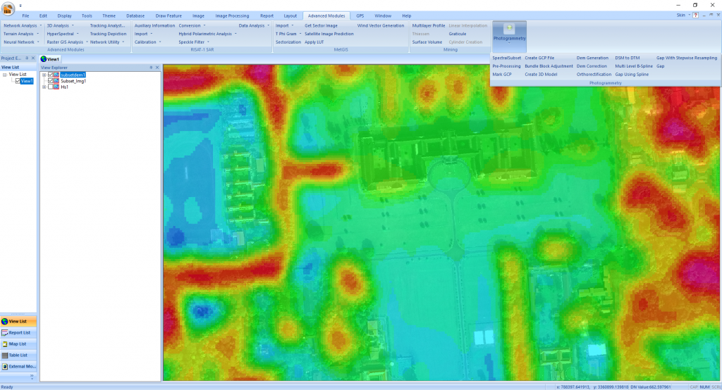
Figure1:
DEM generated from Worldview-3 stereo data (Dehradun City, Uttarakhand, India) using IGiS Photogrammetry Module.
Photogrammetry services in topographic mapping are well established but in recent years the technique has been widely applied in the fields of GIS, architecture, industry, engineering, medicine, geology and many others for the production of precise 3D data. There are many Commercial on the Self (COTS) software available in the market for photogrammetric processing but their higher cost limits the wide user base coming from developing countries like India from adopting Photogrammetry for high-resolution DEM/DEM generation in their applications, which resulted in less accurate earth surface process-related modelling and simulation. To combat this, Scanpoint Geomatics Limited (SGL), India has developed a cost effective and user-friendly photogrammetry module for their IGiS software. The IGiS Photogrammetry Module can process any Stereo data having a rational polynomial coefficient (RPC) file using the Rational Function Model (RFM). However, this module doesn’t need any GCP or match point for the photogrammetric processing, adding some well distributed GCPs, enhances the planimetric and vertical accuracy of the output. This module also provides the functionality of converting the vertical datum to and from ellipsoid to geoid. The module has the automated DEM to DTM generation as well as ortho-rectification tools to generate realistic ortho-images (Figure 2).
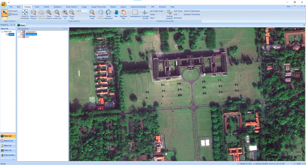
Figure 2:
High-resolution ortho-image (Dehradun City, Uttarakhand, India) generated using Worldview-3 stereo data and generated DEM in IGiS Photogrammetry Module.
Reference:
Roberts, P. O. (1957). An integrated system of highway location analysis using photogrammetry and electronic computers (Doctoral dissertation, Massachusetts Institute of Technology).
Miller, C. L., & Laflamme, R. A. (1958). The Digital Terrain Model-: Theory & Application. MIT Photogrammetry Laboratory.
Maune, D. F., et al., (2001). Accuracy standards. Digital Elevation Models and Applications: The DEM User’s Manual, 61-82.
Singh, M. K., et al., (2015). High-resolution DEM generation for complex snow-covered Indian Himalayan Region using ADS80 aerial push-broom camera: a first time attempt. Arabian Journal of Geosciences, 8(3), 1403-1414.
Latest Blog

Smart Waste Management with GIS
1. Introduction: Waste management entails the responsible collection, processing, and disposal of waste materials with a focus on environmental preservation. Its core objectives include waste reduction, resource recovery, and the....
Read More