GIS for City Traffic and Urban Parking Management
Explore innovative solutions, data-driven strategies, and the latest technologies reshaping the future of smart cities for efficient and sustainable transportation.
Urbanization has been closely related to the economic development of various countries and an attribute of any successful country. This in turn introduces other indices that drive this frontier of development in particular urban development. Transportation is a rapidly growing field that has an important place in human life. It is a key component of urban development that requires a comprehensive strategy to manage.
With the rapid growth of cities and increasing population, urban transportation challenges have intensified. The issue of parking significantly impacts both traffic density and flow rates, consequently influencing the overall efficiency of the transportation network. Ensuring convenient access to parking facilities emerges as a crucial factor in the success and effectiveness of urban land use planning.
Parking activities are integral to roadway systems, yet the concentration of vehicles in urban areas poses a significant threat to the built environment, presenting a challenge for environmentalists. According to an IoT Analytics report, the market investment in smart parking services and products is projected to exceed $3.8 billion by 2023, with an anticipated compound annual growth rate of 14%.
The rising number of vehicles necessitates a corresponding adequacy in parking facilities to meet the growing demand. Urban areas, grappling with irregular construction and rapid population expansion, call for a reconsideration of city planning and the strategic selection of parking locations. This foresight underscores the imperative need to address and implement solutions for the escalating challenges associated with traffic in these areas.
The AHP method, which is one of the MCDM methods, proves effective in addressing site selection challenges. This approach simultaneously assesses a multitude of qualitative and quantitative criteria. Concurrently, GIS technologies employed in the process of selecting parking lots demonstrate the capability to analyse diverse criteria, contributing to a comprehensive and robust decision-making process.
In contemporary urban development initiatives aimed at creating smart cities, there is a notable adoption of advanced strategies and technologies. The fundamental goal of implementing smart city solutions is to enhance the overall quality of life through improved services. Within the spectrum of services integral to smart city projects, the identification and effective monitoring of parking spaces for vehicles hold particular significance. This is crucial for ensuring seamless traffic management, mitigating congestion, and preventing road accidents.
In the realm of free space analysis, Geographic Information System (GIS) emerges as an exceptionally potent tool for elucidating patterns of human activity and their spatial relationships through the lens of geometry and mathematics. By using this technology one can able to detect the free space and areas based on on-road distance between the free spaces-access points and the residential areas.
GIS mobile application is also highly beneficial by offering direct guidance to the closest available parking spaces for drivers, significantly enhancing user convenience. This functionality becomes invaluable as it not only provides optimal route suggestions but also efficiently directs users to nearby parking areas, minimizing time spent in search and contributing to a more streamlined and time-effective navigation experience.
Given the intricate nature of urban transportation networks, which amalgamate multiple modes of transportation within confined spaces in densely populated areas experiencing heightened transportation demand, the utilization of GIS becomes pivotal for addressing and managing traffic-related challenges.
Today, virtually every city and town in the world needs to be concerned with traffic management. Consequently, city planners are well-advised to explore the diverse applications of technology in this domain. Geographic Information System (GIS) proves invaluable in traffic management by contributing to various aspects such as highway maintenance, route planning, and accident analysis. The utilization of GIS technology offers cities and towns the tools needed to enhance their understanding and handling of traffic-related challenges, making it an essential resource for urban planning and management.
1. Maintenance of Highway »
GIS play a pivotal role in optimizing highway maintenance by providing a spatial framework for efficient planning, monitoring, and management of infrastructure assets. Through the integration of spatial data such as road conditions, traffic patterns, and maintenance history, GIS enables highway authorities to make informed decisions regarding maintenance prioritization, resource allocation, and scheduling. This technology facilitates real-time tracking of maintenance activities, aiding in rapid response to emergencies and minimizing downtime.
Additionally, GIS assists in assessing the long-term performance of highways, supporting predictive maintenance strategies and ensuring cost-effective and sustainable maintenance practices. By leveraging spatial intelligence, highway maintenance teams can enhance overall operational effectiveness, extend the lifespan of infrastructure, and contribute to safer and more reliable transportation networks.
2. Traffic Modeling »
A traffic model serves as a mathematical framework enabling planners to analyze the flow of traffic along specific road segments. The concept involves isolating the study area to identify potential enhancements for traffic conditions. The process of traffic modeling encompasses the comprehensive mapping of various factors influencing traffic, such as road dimensions, configuration, vehicle utilization, and ongoing construction projects. GIS proves invaluable in this context by providing satellite imagery that, when combined with surveying, cartography, and data analytics capabilities, facilitates the detailed mapping required for accurate and efficient traffic modeling.
3. Accident Analysis »
Through the integration of various geospatial data layers, such as road networks, traffic flow, weather conditions, and land use, GIS enables analysts to identify high-risk zones, assess the impact of environmental variables on accident occurrences, and devise targeted safety interventions.
Moreover, the seamless integration of GIS with Closed-Circuit Television (CCTV) proves instrumental in swiftly identifying the precise locations of traffic accidents in almost real-time. This capability streamlines the dispatch of first responders to the scene, enabling prompt and efficient resolution of issues. Thus, the collaborative synergy between GIS and CCTV enhances overall emergency management and contributes to a more responsive and resilient transportation system.
4. Route Planning »
GIS, with its capacity to analyze and depict spatial data, proves instrumental in identifying optimal routes by considering crucial terrain features, ultimately contributing to more informed and efficient decision-making in the planning phase.
5. Environmental Impact Assessment »
GIS plays a crucial role in EIA by providing a powerful tool for spatial analysis and visualization of environmental data. Integration of diverse geospatial information, such as land use, topography, hydrology, and biodiversity, enables environmental practitioners to assess the potential impacts of proposed projects on the landscape.
Through the creation of detailed maps and spatial models, GIS enhances the identification, analysis, and communication of environmental risks and opportunities associated with development initiatives, which aids in decision-making processes by offering a comprehensive understanding of the spatial relationships and interactions between various environmental components, contributing to more informed and effective EIA outcomes.
6. Transport Safety Management »
GIS proves instrumental in post-accident analysis, aiding in the identification of accident causes and facilitating preventive measures for future occurrences. It also holds significant value in collecting detailed information about specific locations on roadways, railroad tracks, or near transportation facilities. Access to such comprehensive data not only streamlines proactive planning but also enhances the capacity to avert potential harm.
In conclusion, GIS facilitates the dynamic analysis and visualization of spatial data, enabling city authorities to make well-informed decisions related to traffic flow optimization and parking infrastructure planning.
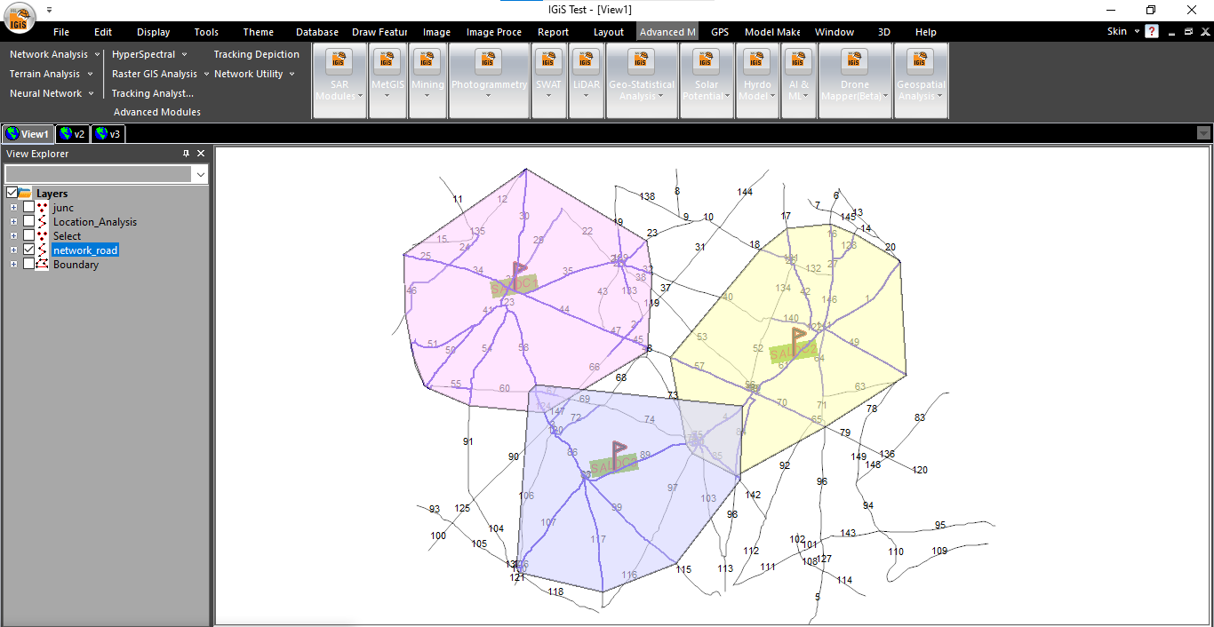
Scanpoint Geomatics Limited, a pioneer organisation has developed a single point geomatics solution i.e. Integrated GIS and Image Processing Software (IGiS), along with an Enterprise level extension. The software has all the capability for image processing and GIS analysis, with advance tools such as Terrain based Analysis, Network Analysis, Microwave Data processing, etc. Additionally, SGL has also introduced its field based mobile application (IGiS-QPAD), an Integrated Survey Solution Mobile Application for the ease of field based activities. This solution can act as a valuable asset for parking inventory, conducting on-site evaluations of current parking assets proves to be the most effective method for creating a comprehensive parking inventory. The data gathered during field assessments can subsequently be enriched with additional details to assist drivers or the public in locating alternative parking options.
The Enterprise solution of IGiS has the provision for spatial data management, real-time transformation of information, integration with other smart traffic systems and geospatial data and service sharing. The ability to assess real-time information, monitor trends, and anticipate future demands positions, it plays a vital tool for creating smarter, more sustainable urban environments. By leveraging IGiS, cities can implement data-driven strategies to alleviate congestion, enhance transportation networks, and streamline parking solutions.
Thus, as cities continue to grow and face evolving mobility challenges, the incorporation of GIS in traffic and parking management proves indispensable for fostering a seamless, accessible, and resilient urban landscape.
Latest Blog

Smart Waste Management with GIS
1. Introduction: Waste management entails the responsible collection, processing, and disposal of waste materials with a focus on environmental preservation. Its core objectives include waste reduction, resource recovery, and the....
Read More